CCTV News: According to China Weather Network, a strong cold air has been "shipped". Today and tomorrow (January 14-15), it will continue to move eastward and south to affect most of the central and eastern regions. The local cooling rate in Jiangnan, Northeast China and other places can exceed 8℃. However, the cold air comes and goes in a hurry. Most of my country has heated up again around the 16th and will enter the "49th" in a sharply warmer manner. The temperature is fluctuating, and the public should pay attention to adding or decreasing clothes in time and beware of colds. At the same time, most of my country has few rains and snow, and meteorological droughts have developed in many places in the south, especially local droughts occur in Guangxi, Guangdong, Hunan and other places, so prevention is needed.
Most of the central and eastern regions are cooling down, and the local decline in Jianghuai and Jiangnan can exceed 8℃
Yesterday, a strong cold air has been "shipped". Affected by it, many places in the north have taken the lead in cooling down. Among them, the temperature in eastern Xinjiang, central and western Inner Mongolia, western Heilongjiang, central and western Tibet, southern Qinghai and other places has dropped by 4 to 8℃, and the local cooling rate exceeds 10℃.
Today, this cold air will continue to move eastward and southward, with temperatures in most central and eastern regions dropping by 4 to 6℃, and local areas such as the eastern northwest region, central and western Inner Mongolia, western North China, Jianghuai, eastern Jiangnan, and central and eastern Northeast China. At the same time, the wind-cold effect in the north is obvious, and some areas such as northern Xinjiang, western Gansu, western Qinghai, central and eastern Inner Mongolia, western Liaoning, Beijing-Tianjin-Hebei, Shanxi, Shandong, Henan and other places will have strong winds of level 5 to 6 and gusts of level 7 to 8.
This week, temperatures in many parts of my country will show a trend of falling first and then rising. Most of the temperatures in the north will drop to lows from the 14th to the 15th and the south will drop to lows from the 15th to the 16th. Especially in the middle and lower reaches of the Yangtze River, which were significantly warm in the early stage, the cooling will be particularly significant. Among big cities, the highest temperature in Shanghai is still 14℃ today, and it will fall to 6℃ the day after tomorrow. The cold will return, and the public needs to add clothes in time to be careful of colds.
However, starting from daytime on the 16th, the temperature in various places will rise again one after another. The highest temperature in most parts of my country will be significantly higher from the 18th to the 19th. The 15℃ line will reach the areas from northern Henan to central Jiangsu and Anhui. The maximum temperature in many places in Jiangnan and South China will exceed 20℃. The warmth during the day is even more prominent than before the cooling down. It will enter the "49th" in a significantly warmer state.
The meteorological drought in the south develops in scattered areas, and precipitation will remain relatively small in the next ten days. Since December 2024, most areas in central and eastern my country have no obvious precipitation, and the meteorological drought in the south develops in scattered areas. At present, some areas in Guangxi, Guangdong, Hunan, Jiangxi, Fujian and other places have reached the level of special drought.
It is expected that in the next ten days, my country will still have less precipitation. Today, weak precipitation will occur along the Yangtze River, Guangdong, Guangxi and other places, but the precipitation intensity will not be large. Among them, there will be light to moderate snow or sleet in some areas such as eastern Inner Mongolia, eastern Heilongjiang, eastern Jilin, Tianshan Mountains in Xinjiang, Hexi, Gansu, northern Shandong Peninsula, western Hubei, eastern Sichuan Plateau, northwestern Guizhou, and northeast Yunnan. Light rain will occur in some areas such as eastern and southwestern Hubei, northern Hunan, Anhui Dabie Mountains, Chongqing, southeastern Sichuan, central and northern Guizhou, southeastern Guangxi, central and western Guangdong, most of Hainan Island, and eastern Taiwan Island, among which moderate rain will occur in some areas such as eastern and western Guangdong and northeastern Hainan Island.
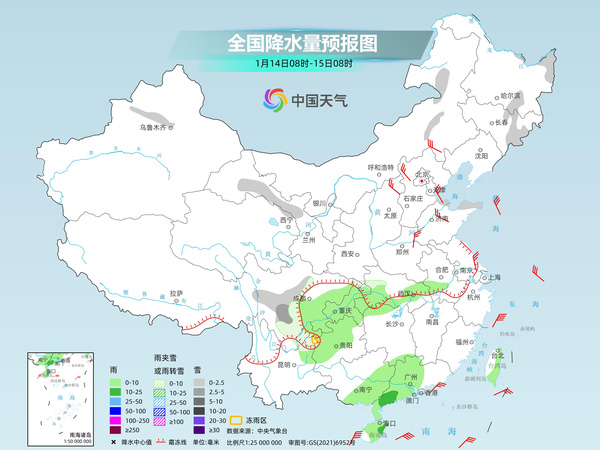
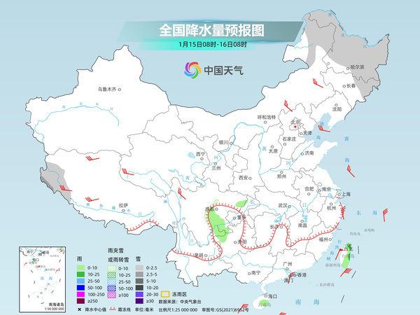
Tomorrow, precipitation weather in my country will continue to shrink, with light snow or sleet in some areas of northeastern Inner Mongolia, most of Heilongjiang, northeastern Jilin, western Tibet, etc., among which moderate snow will occur in some areas of southwestern Tibet. Light rain will occur in some areas such as the eastern and southern Sichuan Basin, northwestern Guizhou, northeastern Yunnan, southeast Hainan Island, and eastern Taiwan Island.
China Weather Network reminds that today, rainfall along the Yangtze River and South China can play a role in moistening dryness, but the intensity is weak and the duration is short, making it difficult to completely alleviate meteorological drought. In the next three days, the forest fire hazards in the above areas will have high meteorological levels and dry weather, so forest fire prevention needs to be done well, the public will raise their safety awareness and pay attention to fire safety at home.