CCTV News: According to China Weather Network, the warm and hot weather in many areas of my country will continue today and tomorrow (April 9 to 10). The highest temperature in most parts of Northeast China will gradually rise to above 20℃, and the highest temperature in the area along the Yangtze River will remain at around 30℃. However, strong cold air will come from the 11th, and the temperature in the central and eastern regions will drop by 6℃ to 10℃, and the local drop can reach more than 12℃. In addition to cooling, precipitation in the north and south will also increase and increase, among which there will be strong rain and snow in eastern Inner Mongolia and northeastern regions.
The warmth of many areas in the central and eastern regions continues. Strong cold air comes from the 11th
Under the influence of cold air, there was a cooling drop in Shanxi, Hebei, Shandong, Henan and other places yesterday, with the drop of more than 10℃ in some areas. However, the range of influence of cold air is limited, and the maximum temperature in many places in the Sichuan Basin to the middle and lower reaches of the Yangtze River is close to or exceeding 30℃.
Today, the temperature in North China and the Huanghuai area will still decline, but will rebound quickly to around 25℃ tomorrow. The highest temperature in most parts of the Northeast will gradually rise to above 20℃ today and tomorrow, while the area along the Yangtze River will maintain a warm weather of around 30℃.
It should be noted that the temperature difference between the north and the middle and lower reaches of the Yangtze River is large, and it is warm in the afternoon but cool in the morning and evening. The temperature difference in many places will exceed 15℃, and locally even exceed 20℃. The public needs to add or reduce clothes in time according to temperature changes.
After the warm early April, strong cold air will affect the central and eastern regions from the 11th to the 12th, and the temperature in many places will drop by 6℃ to 10℃, and the local drop can reach more than 12℃. Around the 12th, the temperature in most areas will turn lower than the same period last year, with few areas with a maximum temperature of more than 30℃ and the maximum temperature of 20℃ will retreat along the Yangtze River.
When cooling down, it will also be accompanied by strong winds. There will be winds of level 5 to 7 in the eastern northwest region, central and eastern Inner Mongolia, western and northern North China, and southern Northeast China, with local gusts of level 8 to 10.
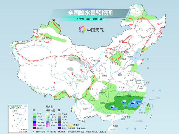
Frequent precipitation in the south is accompanied by strong convective weather. From the 11th, rain and snow in Inner Mongolia in the Northeast region have increased. Today, with the increase in warm and humid airflow, the rainfall range in the south has increased, and the intensity in some areas will also increase, accompanied by strong convective weather. It is expected that light to moderate snow or sleet will be included in some areas of high-altitude areas in northern Xinjiang and mountainous areas in western southern Xinjiang, northeastern Inner Mongolia, northwestern Heilongjiang, northern Qinghai, and Gansu Hexi. Among them, heavy snow will occur in Altay, Xinjiang. There will be moderate to heavy rain in some areas of eastern Guizhou, central and southern Hunan, southern Jiangxi, Fujian, northern Guangxi, Taiwan Island, and other places, and local heavy rain.
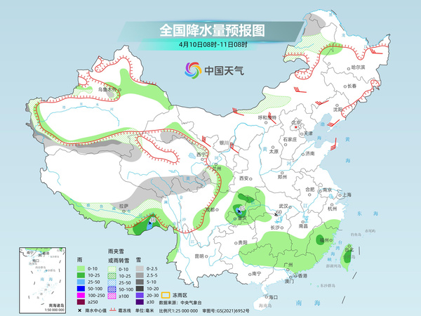
Tomorrow, as the shear system moves eastward, precipitation in the south weakens. It is expected that light to moderate snow or sleet will be found in some areas such as northeast Inner Mongolia, the southern Xinjiang Basin and the mountainous areas of western southern Xinjiang, eastern and southern Tibet, southern Qinghai, Gansu Hexi, and northern Sichuan Plateau. There will be light to moderate rain in some areas such as eastern Xinjiang, southeastern Tibet, southern Gansu, eastern Sichuan Basin, western Jianghan, central and southern Jiangnan, central and northern South China, and Taiwan Island. Among them, there will be heavy rain in some areas such as southeastern Tibet and central Chongqing.
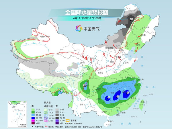
From the 11th, under the influence of a new round of strong cold air, precipitation in the north and south will increase again. It is expected that light to moderate snow or sleet will be found in some areas of the mountainous areas in western Xinjiang, central and eastern Inner Mongolia, northwestern Heilongjiang, central and northern Tibet, southern and western Qinghai, northern Hebei, northern Sichuan Plateau, and other areas. Among them, heavy snow will be found in some areas of northeast Inner Mongolia, northwestern Heilongjiang, and local blizzards will be found. There will be moderate to heavy rain in some areas of the southwest region, Jianghan, western Jianghuai, most of Jiangnan, northern southern China, and other areas, among which there will be heavy rain in some areas of central and western Hunan, most of Jiangxi, northwestern Fujian, and northern Guangxi.
China Weather Network reminds that there has been frequent rainfall in the south recently, and some areas will also be accompanied by strong convective weather. The public should pay attention to traffic safety when traveling, and pay attention to preventing strong convective weather such as short-term heavy rainfall, thunderstorms and strong winds. Starting from the 11th, there will be strong rain and snow in eastern and northeastern Inner Mongolia. The public should pay attention to local forecast and warning information and take precautions in advance.