CCTV News: According to China Weather Network, affected by strong cold air, the weather in central and eastern my country is very complicated for three days (April 11 to 13), with heavy cooling, strong rain and snow, strong convection, strong winds and sandstorms appearing one after another. It should be noted that local gusts of 12 to 13 may occur in local areas in the eastern part of the northwest region, North China, eastern Huanghuai, etc., local areas in the northeast may encounter heavy blizzards. The southern region will face the strongest wind and hail weather this year. It is recommended that the public minimize going out and pay attention to safety.
Many places in the central and eastern regions will face severe cooling. When wind and sand hit in the northern region, we need to be wary of extreme winds. Since April, the temperature in most parts of the country has been mainly rebounding. The process of spring in the north continues to advance northward, and the south is warmer. Yesterday, the maximum temperature of 20℃ line rushed north to northern Heilongjiang, with the maximum temperature in central and southern North China and some areas south of North China exceeding 25℃, and many places along the Yangtze River exceeding 30℃.
However, the warm weather pattern is about to change. Today and tomorrow, affected by strong cold air, the temperature in most parts of the central and eastern regions will drop by 6 to 10℃. Among them, the local cooling range in the eastern part of the northwest, central and eastern Inner Mongolia, western and northern North China, southern Northeast China, and eastern Jianghuai can reach 12 to 16℃.
It is expected that the 12th will be the core period for cooling. The daily drop in major cities such as Shenyang, Hohhot, Taiyuan, Beijing, Tianjin, Shijiazhuang, Jinan, Zhengzhou, Hefei can exceed 10℃ in a single day. After the cooling, the temperature will turn to a significantly lower state than the same period in the previous year.
In addition to the heavy cooling, this strong cold air has also outstanding ability to create strong winds. April is a period of frequent strong winds in the northern region. From the 11th to the 13th, cold air and afternoon momentum are transmitted, which increases the strong wind. It is expected that there will be gusts of 8 to 10 in the eastern part of the Northwest region, western and northern North China, southern Northeast China, and eastern waters, and locally reach levels 11 to 13.
There will be gusts of 9 to 11 in the eastern part of the northwest region, North China, eastern Huanghuai and eastern waters, and locally reach levels 12 to 13. The wind force in North China, eastern Huanghuai and other places may exceed the extreme value of the same period in the local April historical period. At the same time, affected by cold air and strong winds, there will be large-scale sandstorms in the northern region today. Southern Xinjiang, western Inner Mongolia, western Gansu and other places need to be wary of sandstorms.
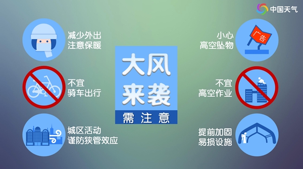
China Weather Network reminds that the strong winds last for a long time and have a wide impact range. The strong winds in North China on the 12th may be extreme and catastrophic. It is recommended that the public minimize going out and properly place outdoor items. If you go out, pay attention to wind prevention. If you are going out, be vigilant about the narrow-tube effect of urban activities. Do not stay under big trees, tall buildings, or temporary buildings, and be careful of falling objects from high altitudes.
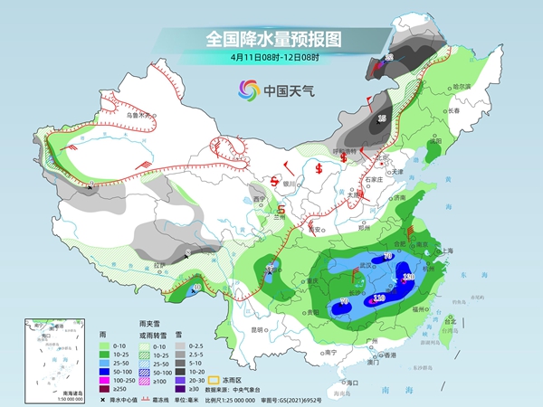
The northeastern region and other places will encounter strong rain and snow. The strongest wind and hail weather this year may appear in the south. With the strong cold air coming on, three days from today, eastern Inner Mongolia and Northeastern regions will encounter strong rain and snow. The strongest snowfall period will occur between the night of the 11th and the night of the 12th. At the same time, the southern region may see the strongest wind and hail weather this year two days ago and tomorrow. Some areas in Hubei, Hunan, Anhui, Jiangxi, Zhejiang, Fujian, Guangxi and other places need to prevent heavy rainfall today.
The Central Meteorological Observatory predicts that today, there will be light to moderate snow or sleet in most of Inner Mongolia, northwestern Heilongjiang, mountainous areas in western southern Xinjiang, central and eastern Qinghai-Tibet Plateau, among which there will be heavy to moderate snow in some areas in central and eastern Inner Mongolia, western Heilongjiang, northeastern Tibet, and other areas, including heavy snow in some areas in northeastern Inner Mongolia. There will be heavy to torrential rains in some areas such as Hubei, southeastern Henan, central and southern Anhui, western Zhejiang, northwestern Fujian, central and northern Jiangxi, eastern and southern Hunan, northern Guangxi, western Sichuan Basin, and southeastern Tibet. Among them, there will be heavy torrential rains in local areas such as eastern Hunan, western Jiangxi and northern Jiangxi.
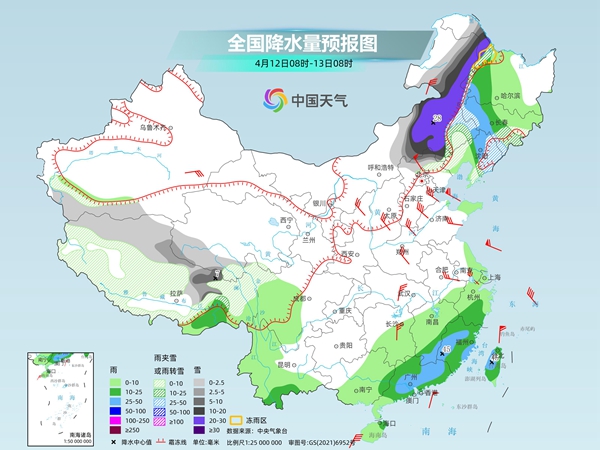
Tomorrow, there will be light to moderate snow or sleet in some areas of central and eastern Inner Mongolia, northwestern Heilongjiang, northwestern Heilongjiang, eastern Liaoning, and most of the Qinghai-Tibet Plateau. Among them, there will be heavy to moderate snow in some areas of central and eastern Inner Mongolia, northwestern Heilongjiang, western Jilin, eastern Liaoning, and northern Hebei. There will be heavy to blizzards in some areas of local heavy snow, and freezing rain in some areas of western Heilongjiang. There will be light to moderate rain in some areas of the central and western Northeast region, southeastern Tibet, western Sichuan, western and southern Yunnan, eastern Jianghuai, most of Jiangnan, and most of South China. Among them, there will be heavy rain in some areas of the central and western Northeast region, southern Jiangnan, and eastern South China.
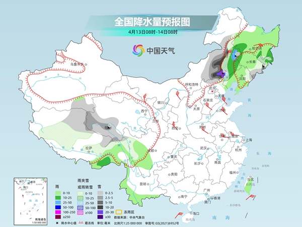
The day after tomorrow, there will be light to moderate snow or sleet in eastern Inner Mongolia, eastern Jilin, northern Hebei, northern Tibet and southwestern Qinghai. Among them, there will be heavy to moderate snow in some areas of eastern Inner Mongolia, northern Hebei, and some areas of heavy snow in some areas of eastern Inner Mongolia, northern Hebei, and local heavy snow. There will be light to moderate rain in some areas such as most of the Northeast, southeastern Tibet, western Sichuan, western and southern Yunnan, and Taiwan Island.
China Weather Network reminds that during the rain and snow in the north, the snowfall in central and eastern Inner Mongolia, northwestern Heilongjiang, eastern Jilin, and northeastern Liaoning is highly intense, which is not conducive to transportation and agricultural and animal husbandry production. The public needs to do a good job in strengthening greenhouses, simple buildings, and livestock sheds. From the afternoon of the 11th to the evening of the 12th, there will be large-scale strong convective weather in southern Jianghuai, southern Jiangnan, southern China and eastern Southwest China, and there will be thunderstorms, strong winds or hail in some places at level 12 or above. It is recommended that the public minimize going out and pay attention to safety.