CCTV News: According to China Weather Network, from today (January 25th) to 27th, the first cold wave weather process this year will continue to affect our country. Rain and snow weather in the central and eastern parts is still at its peak and will spread eastward. There was heavy snowfall in places such as North China and Northeast China. At the same time, more areas in the central and eastern regions will experience significant cooling. The cumulative temperature drop in many places in the north can reach more than 14°C, and the lowest temperature in some areas of North China and Huanghuai may be below minus 10°C. It is the peak period of Spring Festival travel. The public should pay attention to keeping warm and keep warm, and pay attention to traffic safety when traveling in rainy and snowy weather.
Heavy snowfall in the north continues to develop eastward, and there are local heavy snowfalls in North and Northeast China
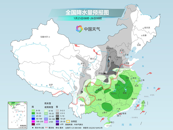
Yesterday, the most extensive and intense rain and snow weather process in China since this winter entered its strongest period, monitoring It shows that yesterday, snowfall, sleet or rain turned to snow occurred in parts of central and eastern Gansu, eastern Qinghai, western Inner Mongolia, Ningxia, central and northern Shaanxi, western and southern Shanxi, and central and western Henan. Among them, eastern Gansu and central Shaanxi Heavy snowstorms occurred in some areas in Henan, Henan and other places, and heavy snowstorms occurred locally.
In the next three days, snowfall in northern my country will continue to expand eastward. Snowfall will continue to occur in parts of North China, Northeast China and other places, with localized heavy snowfall. There will still be rainfall in most of the south today, and it will stop gradually from northwest to southeast over the next two days.
Specifically, the Central Meteorological Observatory predicts that today, central and eastern Inner Mongolia, eastern Qinghai, western Gansu, western Sichuan Plateau, Shaanxi, Shanxi, Hebei, Beijing, Tianjin, central and western Shandong, Henan, northwest Hubei, There will be light to moderate snow or sleet in some areas in the mountainous areas of western Anhui and northeastern Yunnan. Among them, there will be heavy snow or sleet in some areas in western and northern Henan, central and southern Shaanxi, northwest Hubei, western and southern Shanxi, and southern Sichuan Plateau. to blizzard. There are moderate rains in parts of Chongqing, northeastern Guangxi, northern and eastern Hunan, southeastern Hubei, central and northern Jiangxi, western Anhui, northwest Fujian, and western Zhejiang. There are strong winds of magnitude 5 to 6 and gusts of magnitude 7 to 8 in central and western Inner Mongolia, southern Tibet, most of Qinghai, Hexi of Gansu, most of Ningxia, Shanxi, and central and eastern Sichuan.
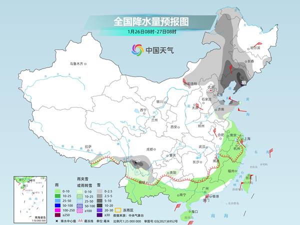
Tomorrow, there will be light to moderate snow or snow in parts of central and eastern Inner Mongolia, eastern and northern Hebei, Tianjin, Beijing, Shandong, Liaoning, western and southern Jilin, southern Sichuan Plateau, northern Yunnan, and central Guizhou. Sleet and snow, including heavy snowfall and local heavy snowfall in some areas of southeastern Inner Mongolia, Liaoning, and southern Sichuan Plateau. There will be light rain in parts of southern Anhui, most of Jiangsu, Shanghai, eastern and southern Jiangxi, Zhejiang, Fujian, central and southern Yunnan, central and southern Guangxi, most of Guangdong, and Taiwan Island.
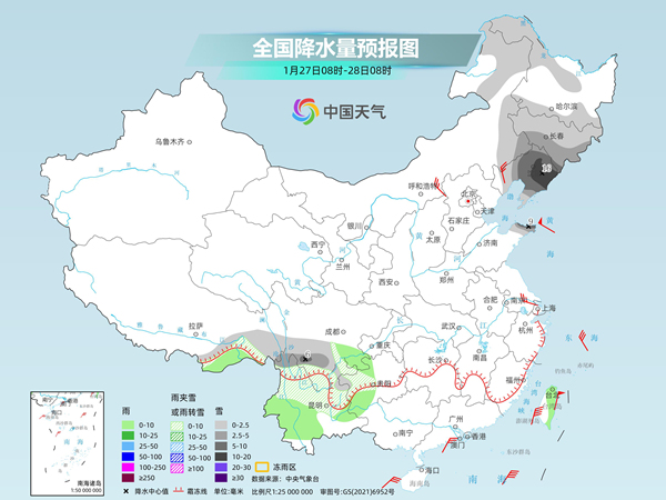
The day after tomorrow, there will be light to moderate snow or rain in parts of northeastern Inner Mongolia, northwest and southern Heilongjiang, Jilin, Liaoning, Shandong Peninsula, southeastern Tibet, southern Sichuan Plateau, northern Yunnan, and western Guizhou. There was mixed snow, including heavy snow and local heavy snowfall in some areas in central and eastern Liaoning, northern Shandong Peninsula, and southern Sichuan Plateau. There will be light rain in parts of southeastern Tibet, southwestern Yunnan, southeastern Sichuan, southwestern Guizhou, northern and eastern Taiwan Island and other places.
The meteorological department reminds that today and tomorrow, there will be widespread snowfall in China, with heavy snowfall in some areas. There will also be phase changes of rain and snow in Shaanxi, Henan and other places, which will easily lead to snow and ice on the road. Visibility reduced. It is the peak period of Spring Festival travel. The public should drive slowly and carefully when going out and pay attention to traffic safety.
In the next three days, the cold wave will continue to move eastward and southward, and the temperature will drop violently in the north. The local drop may exceed 20℃
Yesterday, the first cold wave this year continued to exert force, and the cooling range developed eastward, with the northwest region The temperature dropped significantly in some parts of the east. The temperature in Lanzhou was around freezing point all day long, and it was freezing cold.
In the next three days, as the cold wave moves eastward and southward, the cooling will quickly affect most of the central and eastern regions. The Central Meteorological Observatory issued a yellow cold wave warning this morning. From January 25 to 27, the temperature in most of my country will drop by 8 to 12 degrees Celsius. The temperature drop in the eastern northwest region, western North China, and the Western Sichuan Plateau can reach more than 14 degrees Celsius. From the morning of the 27th to the 28th, the minimum temperature line of 0℃ will press south to the area from northern Yunnan to southern Jiangnan.
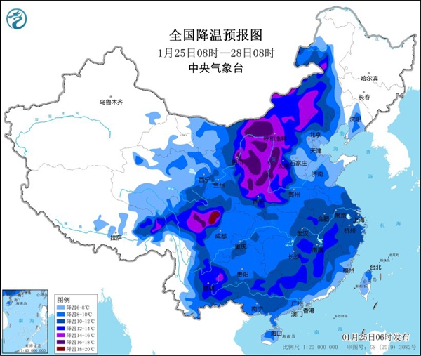
The core cooling area of this cold wave is located from the eastern part of Northwest China to the western part of North China. Starting today, the above-mentioned areas will experience severe cooling. It is expected that the cumulative drop in the next three days will reach 16°C or even more than 20°C. Temperatures have hit new lows this winter. The temperature in northwest China will basically complete the reversal from high to low today and tomorrow, and the temperature in North China will gradually turn to low tomorrow and the day after tomorrow.
In cities, the highest temperatures were -6℃ in Lanzhou on the 26th, -6℃ in Yinchuan on the 26th, and -4℃ in Taiyuan on the 26th, which were significantly lower than the same period in late January. The May 9th holiday started with a strong cold atmosphere. The public is advised to take precautions against the cold and keep warm.
In addition to the north, some areas in the south will also face significant cooling in the next three days, accompanied by rainfall and a feeling of humidity and coldness. Especially in some areas such as eastern Yunnan, southern Jiangnan, and northern South China, the temperature drop can reach more than 10°C, and even reach 20°C in some places. For example, in Kunming, the highest temperature today is 19°C, and tomorrow it will drop to only 2°C, with fluctuations in temperature and temperature. The general public is advised to wear warm clothes in time to prevent colds and cardiovascular and cerebrovascular diseases.